The captain's final travel letter
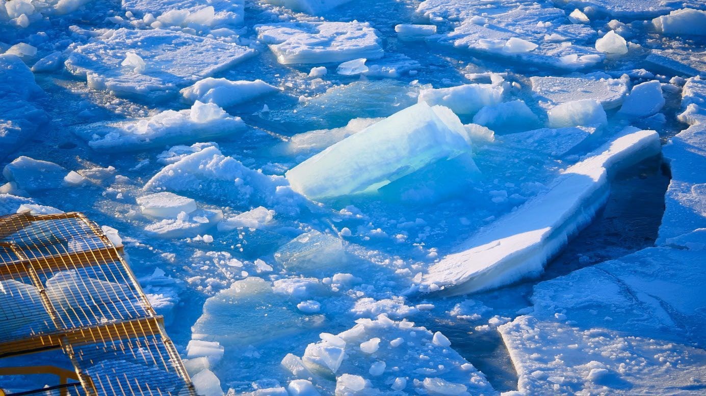 Blue ice. Photo: Mattias Petersson.
The Arctic Ocean, 2025-09-16
Hello everyone!
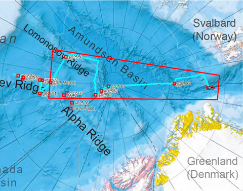
We have now reached the final week of this expedition. At the time of writing, we are on our way to the last station, where we will deploy a buoy on the seabed equipped with several instruments to measure the water passing by during its deployment. The weather has given us sunshine, fog, and snow, and the ice has offered considerable resistance as we sailed up towards the North Pole from E140 and down towards N84° around the Greenwich meridian.
Navigation
It has continued to be both challenging and rewarding to sail Oden and master the ice. The ice has been similar to what we encountered earlier, which is not surprising since we have been navigating back through the same area. Since the last letter, we have been completely on our own, without assistance from LSSL, which may explain why our route has been more direct this time. We are now at the ice edge, carrying out the final research work, and tomorrow we set course for Longyearbyen for the conclusion of the expedition and crew change. At times, navigation has been demanding, and Oden has had to work hard to make progress—but she has done so with flying colours. The floes we are currently in are of the two-year type, about two metres thick, but no larger than 30 by 30 metres, so they are not too difficult to pass.
Marine geology
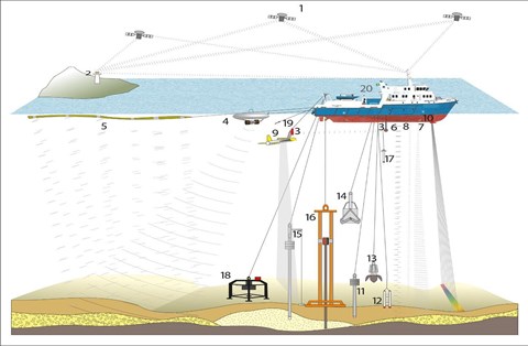
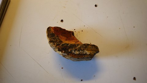
The researchers have collected sediment cores from the seabed using several types of samplers. These cores can be up to 6–8 million years old and reveal much about past climates. During one sampling, a stone was brought up instead of sediment. While I thought this was a failure, the researchers were delighted—the stone turned out to be about 100 million years old.
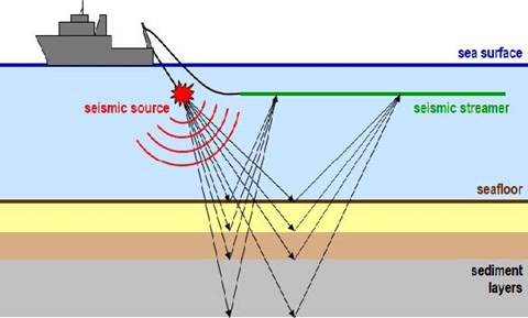
Seismic Using
Using sound waves, researchers study the bedrock beneath the seabed. Air cannons firing at 180 bar create powerful bangs and vibrations throughout the ship. “Music to my ears,” said the Chief Geologist. I am not entirely sure I agree, but it is certainly impressive equipment.
Geophysical mapping
Throughout the expedition, continuous measurements of the seabed and underlying sediments have been carried out using echo sounders and sub-bottom profilers. Combined with seismic studies, this work forms an important part of the Canadian UNCLOS investigation. For example, with a depth of 4,200 metres at the North Pole, the multibeam sounder provides a footprint of about 42 kilometres across—an impressive scope.
Properties of sea ice
We have investigated how the ice moves, melts, freezes, and deforms. GPS buoys have been placed on floes to measure drift and rotation, while snow thickness, temperature, ice structure, and salinity have also been recorded.
Water samples
Samples from various depths have been taken to trace the origin of water masses from both the Atlantic and Pacific Oceans, and to better understand greenhouse gas exchanges between ocean and atmosphere.
Biogeochemistry
This research focuses on phytoplankton, which capture carbon dioxide and form the basis of the food chain. Samples from different depths and environments—on, in, and under the ice—help clarify how biological processes regulate the Arctic carbon cycle.
Oceanography
The researchers analyse the properties of the water, as well as mixing processes and movements beneath the ice. Using various instruments, they measure temperature, salinity, density, and turbulence. This research improves our understanding of how storms, meltwater, and the structure of the ice affect the ocean.
Meteorology
A comprehensive program of meteorological instruments continuously measures wind, temperature, humidity and clouds. Weather balloons are sent up twice a day with radiosondes whose data also goes to the global forecast system. Radar and lidar analyse the clouds.
Mercury tracking
Mercury can move from the ocean to the air via sea spray. The research provides insights into how mercury is spread in the Arctic and how it affects ecosystems.
Artist
Artist Sara-Vide Ericson is participating in the expedition. Her artistic work interprets the landscape, ice and human presence in the Arctic space, and will contribute to a visual perspective of the expedition through her eyes. It is always interesting to see how someone who does not necessarily need to be familiar with the work of either the scientists or the crew, but gives an interpretation of the impression she has received.
Teacher
Teacher Cristina Bernardez has implemented the project Float Your Boat, where hundreds of small wooden boats decorated by students are placed on the ice at the North Pole together with a satellite buoy that can be followed online. The boats are used to study ocean currents in the Arctic, and their movements can be followed via the web at https://iabp.apl.uw.edu/IABP_Maps.html. Cristina's buoy is nr 147.
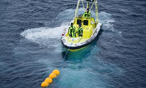
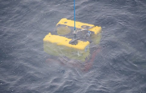
Bottom-anchored buoy
Here we have placed an advanced measuring station (so-called mooring) on the seabed. It collects data on temperature, currents and other parameters over a longer period of time. We deployed this measuring station on Monday with the help of Oden's Fast Rescue Craft (FRC) and crane, and the launch was a great success. This is a Norwegian project, but they have no participants on board, so this launch was done by the technicians from the Swedish Polar Research Secretariat and Oden's crew.
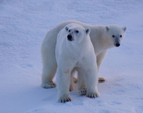
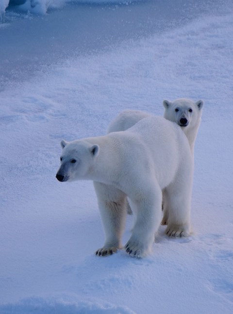
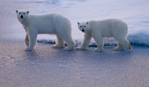
Wildlife
Wildlife sightings have been rare, but this weekend we finally observed polar bears—two, at close range. We have also seen seabirds throughout the expedition, including kittiwakes and, most recently, an ivory gull.
Life on board
Life on board remains good-humoured, and tomorrow the ping pong tournament between the ship’s doctor and one of the students will be decided.
As we approach the end of this expedition, I thank everyone for their hard work and good spirits. On Friday, we will disembark and return home to our families.
You can read more about the research and events of the expedition at www.polar.se.
With warm regards,
Mattias Petersson, Captain of Oden